
When the ocean reaches further

What udha is, why it is growing and why warnings fail.

Artwork: Dosain

Artwork: Dosain

2 hours ago
Every year, between May and August, footage begins circulating of waves surging over harbour walls and washing through the streets of islands in the Maldives. Homes impacted, businesses flooded, farms ruined, and groundwater contaminated. Maldivians refer to this as “udha” (likely originating from “Udhaka” in the Sanskrit language meaning “water” or “salt”). It is scientifically referred to by a variety of names including “swell flooding”, “wind-wave flooding” or “wave-driven/wave-induced flooding”, hinting at the wave-related cause of these floods.
Over the past decade, significant research has been done to identify how, why, and how often this happens. From analysis of extreme historical flooding events in April 1987 and May 2007, to numerical modelling of water levels at the shoreline to understand the extent to which different tide, wave, and other coastal processes contribute to udha. Understanding it, and what it isn’t, is the first step towards predicting it and living with it more safely.

Overtopping is not udha

Whenever water spills over a harbour wall or revetment during a high tide or choppy conditions, it is not always an udha event in the scientific sense. It is more likely to be a case of wave overtopping. These overtopping events are more and more common in the present day when land reclamation or infrastructure such as the approach to the Sinamalé bridge or the Malé industrial zone, have pushed island boundaries out to where the ocean forces are so strong that a natural beach boundary will not hold without significant coastal protection. If designed properly, coastal structures are engineered to hold back just enough of the ocean to maintain safety on a day-to-day basis. But frequent overtopping of these structures can point to design or structural shortfalls such as being built too low, too steep, or in a way that concentrates wave energy rather than dissipate it.

What is udha?

Udha is different. Extreme cases of udha (as opposed to nuisance udha) – like those in April 1987, May 2007, and July 2022 originates far from the Maldives in the Southern Ocean between roughly 40° and 50° south called the "Roaring Forties," where strong winds persist throughout the year, creating large waves. These waves form around the south tip of Africa, east of South America, or southwestern coast of Australia. They travel all the way across the Indian Ocean and arrive at the Maldives as as powerful swells.
The swells break on the shallow reefs and pile water onto the reef flat in a process coastal scientists refer to as wave set-up, and make its way up the shoreline and onto the coast as wave run-up. Wave setup and run-up can add several tens of centimetres to more than a metre of water on top of the tide. This is enough to overwhelm even a well-designed coastal defence when conditions are extreme. Unlike overtopping which happens close to the harbour, revetment, or seawall, udha penetrates far into the island. The long-period swells that cause udha contain a very low frequency wave (infra-gravity wave) whose contribution is significantly increased over the reef flat, causing high run-up and wide-spread flooding. Because udha is not necessarily related to rain, it can even happen on the sunniest of days.
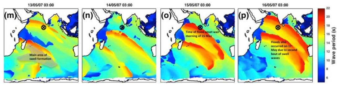
The April 1987 flood, which swamped the reclaimed areas in Malé and Hulhulé airport, was traced to a storm in the Southern Ocean that generated 15–16-second swells. Similarly the May 2007 event, which flooded 88 islands across 18 atolls and forced the evacuation of more than 1,600 people, was generated by an intense storm south of Africa that generated 18–20-second period. This particular event led to the loss of several lives in Mauritius and Réunion before reaching the Maldives. The image below shows this particular swell moving up the Indian Ocean towards the Maldives. The most recent major event, on 1 July 2022, followed the same pattern: a distant swell arriving with a 20-second period, this time coinciding with an unusually high tide to flood 20 islands across Thaa, Huvadhoo and Addu atolls in what was reported as the worst flooding in the region since the 2004 tsunami.
Swell period in the Indian Ocean prior to the 2007 May udha event. Image from Wadey et al., 2017.
These udha events most often happen during the Hulhuangu (southwest) monsoon. This is when the Roaring Forties expands northwards towards the equator and can gives rise to strong storms that generate these swell waves. As a result, minor nuisance udha is common during the southwest monsoon, especially on islands located on the southwestern rim of the Maldives. For these islands nuisance udha has historically been treated as an almost annual expectation. The rarer, extreme, and more damaging udha events are typically a result of a long-period swell arriving at a spring high tide, interacting with the coastal zone and causing extreme wave setup, or being associated with extreme wave heights as in the case of the April 1987 event.

A hazard likely to grow

Researchers who study the exposure of Maldives to udha are consistent on one point: these events are on track to become both more frequent and more intense over the coming decades. This is not just because Southern Ocean storms are intensifying, but has to do with changes in almost all factors that contribute to udha. Sea level rise increases the depth of water present on the reef flat during high tides, allowing larger waves to reach the shoreline. Frequent coral bleaching events have reduced the resilience of the reefs, which had previously helped to dissipate the energy of the swells. Coastal erosion on inhabited islands has reduced the sand which acts as a buffer between the land and the waves.
What is today a rare, generation-defining event is on course to become a routine one within our lifetime.
A study exploring the frequency of udha occurrences in the Maldives concluded that extreme udha events which at present happen once every 25 years, could by 2050 start happening every few years. Of the 158 major udha events identified in the south of the Maldives between 1990 and 2023, only three had ever produced severe impacts. However, the same analysis found that if these events occurred in 2050, at least 25 of those events would result in significant damage.

Can it be predicted to give reliable early warnings?
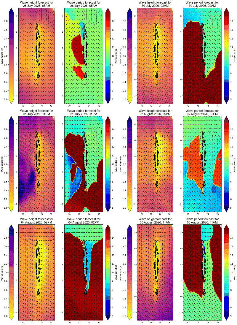
Ocean swell is, in principle, one of the more forecastable hazards the Maldives faces. Southern Ocean storms are tracked by satellite, and the swell they generate travels at predictable speeds across open water, giving several days of theoretical lead time. In fact, it was reported that since 2013, the Maldives has been receiving three-day-ahead "high wave alerts" (typically triggered above 3-metre swell) via a partnership with India's National Centre for Ocean Information Services (INCOIS).
In practice, however, turning a swell forecast into a genuinely reliable, island-specific warning remains difficult. As said previously, udha is generally a combination of tides, waves, and their interaction with the reefs. So accurate prediction requires combining the swell forecast with precise tide timing and then modelling how the combined water level will interact with the exact depth and shape of each and every individual island.
But global wave models can significantly misjudge conditions at the coast of islands on the rim of atolls. This error is more pronounced if an island is located inside an atoll and not on the rim. So accurate warnings that people are confident in acting upon (false positive and negatives can completely change how those at risk act on warnings), can only be achieved though the use of locally calibrated models with up-to-date data on reef and shoreline conditions, supplemented with buoy data to verify uncertainty of wave forecasts, and incorporating probability estimates to quantify the error in the prediction.
Ten-day forecast of wave height (left) and wave period(right) forecasts from NOAA's global wave forecasting system over the Maldives.
This is is not something that cannot be achieved. The bottleneck has historically been computational. Simulating the interaction of the tides and waves with the reef and shoreline traditionally required computationally expensive numerical models, which are far too slow to run in real time for thousands of islands at once. But researchers have increasingly been developing simplified models that reproduce the same behaviour in a fraction of the time. Combined with the sharp and ongoing fall in the cost of computing power, cloud-based processing, and increasingly accessible data (satellite and reanalysis), the pieces needed for a much faster, island-specific forecasting system are largely already available.
Unfortunately, the Maldives still lacks this. Not because of a technological barrier but rather an infrastructure gap. Closing that gap will require exactly what researchers have been calling for since the 1987 event: more wave buoys, more tide gauges, sustained monitoring, and the institutional capacity to set up and run these. It is a shame that we are still no closer to this than we were 20 years ago. We do not need data to show that udha events are becoming more frequent. We can see it with our own eyes. Continued failure to provide adequate warning for a known risk where clear indications have been given about the increased impacts not only puts the safety of the people at risk but also compromises energy, water, and food security of the Maldives.
Dr Nashwan Matheen is a coastal engineer and researcher. 
Sources:
1-

Wadey, M., Brown, S., Nicholls, R. J., & Haigh, I. (2017). Coastal flooding in the Maldives: an assessment of historic events and their implications. Natural Hazards. eprints.soton.ac.uk/412275

2-

Amores, A., Marcos, M., Pedreros, R., et al. (2021). Coastal flooding in the Maldives induced by mean sea-level rise and wind-waves. Frontiers in Marine Science, 8, 665672.

3-

Amores, A., Marcos, M., Le Cozannet, G., & Hinkel, J. (2022). Coastal flooding and mean sea-level rise allowances in atoll island. Scientific Reports, 12, 1281.

4-

Masselink, G., Poate, T., Scott, T., Roelvink, F., & McCall, R. (2025). Numerical modelling of the 1 July 2022 flooding event, Southwest Huvadhoo Atoll, Maldives. Cambridge Prisms: Coastal Futures, 3, e23.

5-

Brown, S., Wadey, M. P., Nicholls, R. J., et al. (2020). Land raising as a solution to sea-level rise: an analysis of coastal flooding on an artificial island in the Maldives. Journal of Flood Risk Management, 13, e12567.

6-

Roelvink, F. E., Masselink, G., Stokes, C., & McCall, R. T. (2025). Climate adaptation for a natural atoll island in the Maldives. Earth’s Future, 13, e2024EF005576.

7-

Storlazzi, C. D., Gingerich, S. B., van Dongeren, A., et al. (2018). Most atolls will be uninhabitable by the mid-21st century because of sea-level rise exacerbating wave-driven flooding. Science Advances, 4(4), eaap9741. doi.org/10.1126/sciadv.aap9741

Discussion

No comments yet. Be the first to share your thoughts!

No comments yet. Be the first to join the conversation!

Join the Conversation

Sign in to share your thoughts under an alias and take part in the discussion. Independent journalism thrives on open, respectful debate — your voice matters.

Support Independent Journalism

Help us keep the news free and fearless

Give once

or
Become a memberfrom $5/month