Younger than the pyramids: teaching students how the Maldives really formed
A new textbook replaces Darwin's theory with what drill cores actually show.
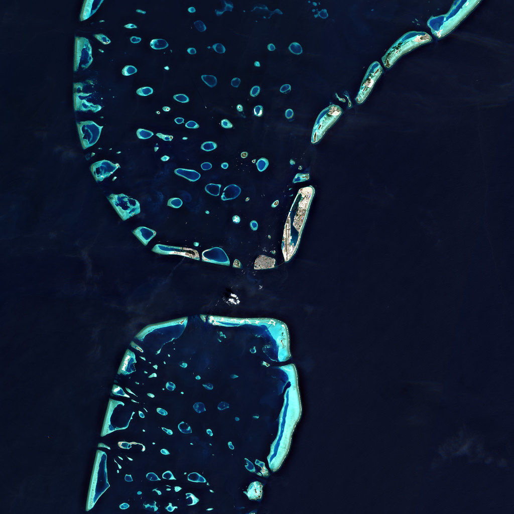
Artwork: Dosain
04 Mar, 14:24
For generations, Maldivian students learned that their islands formed through the slow sinking of ancient volcanoes, an elegant and intuitive theory proposed by Charles Darwin in 1842 that remains in textbooks worldwide. But a new supplementary curriculum is now teaching them what drill cores and seismic surveys have revealed: Darwin was working with incomplete information, and the real story is both stranger and more relevant to the future of a low-lying archipelago facing accelerated sea level rise.
"Darwin was right with the data he had," said André Droxler, an emeritus professor of marine geology at Rice University in Texas who spent four months at the Maldives National University in 2023 as a Fulbright scholar. "And he was well, well ahead of his time to come up with something like this. But who are wrong are the teachers or the people like me who are not able to convince students, but also the public about this."
Droxler spoke to the Maldives Independent about the push for curriculum change after previous efforts to communicate the new science, "only by giving courses, by talking to the government."
The result of that Fulbright residency is now in classrooms: "Atoll and Island Formation in the Maldives," a teacher's guide with activities spanning Key Stages 1 through 4. Developed under a grant by the Maldives National University and endorsed by the National Institute of Education, the book was co-authored by Mohamed Didi, Dr Aminath Shiyama, and Dr Fathimath Shafeeqa. Copies were printed with funding from the Atmosphere Foundation.
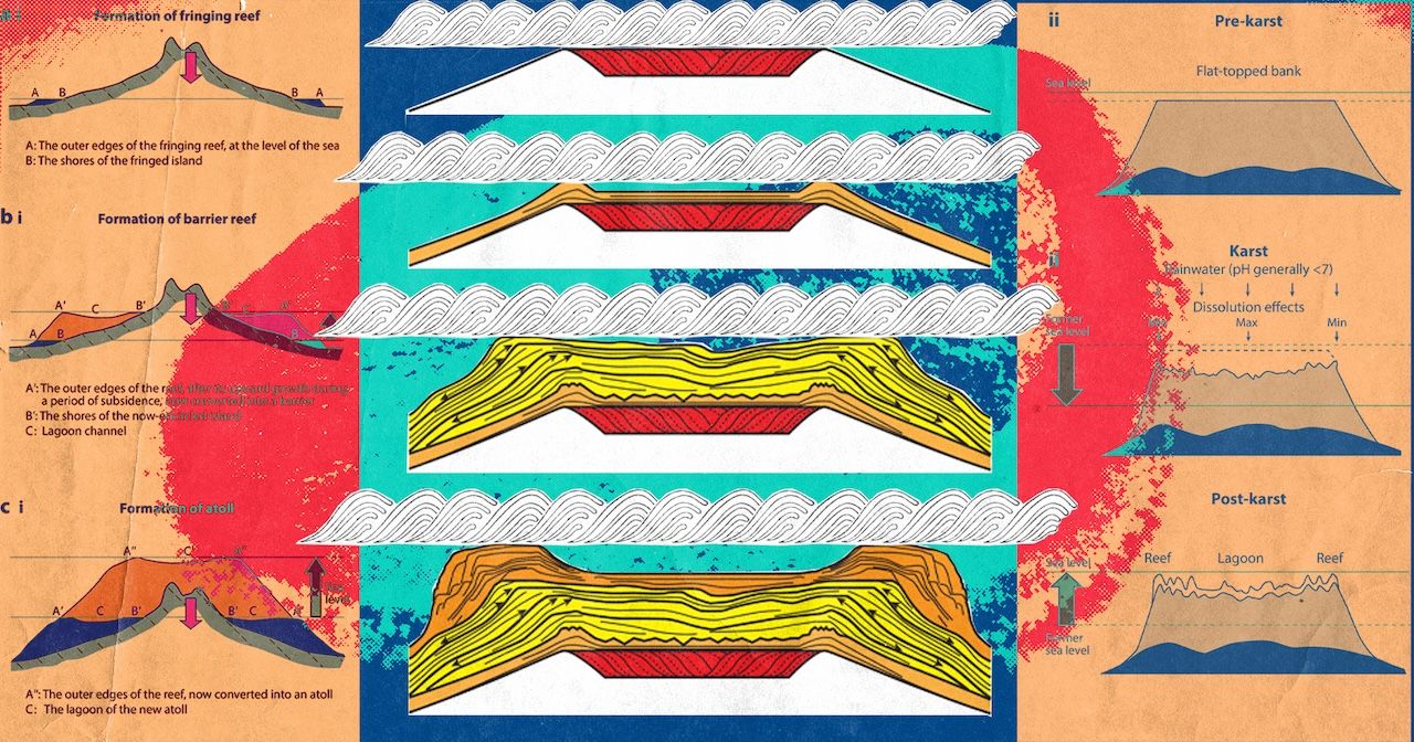
"Based on the limited data at hand, Darwin linked those three types of reefs [fringing reefs attached to volcanic islands, barrier reefs separated from them by lagoons, and ring-shaped atolls] together in an evolutionary model that elegantly explained their interrelated origin," the teacher notes observed. "The simple logic of his model was (and still is!) very pleasing and, therefore, has been generally accepted since its initial publication."
What lies beneath
Students learn that the islands they live on – everything above water – represent merely 0.001 percent of the Maldives' actual mass. Beneath them lies a limestone platform 800 kilometres long, 130 kilometres wide, and averaging two to three kilometres in thickness. This platform was built by corals: 55 million years of reef organisms growing, dying, and becoming rock, each generation building on the remains of the last.
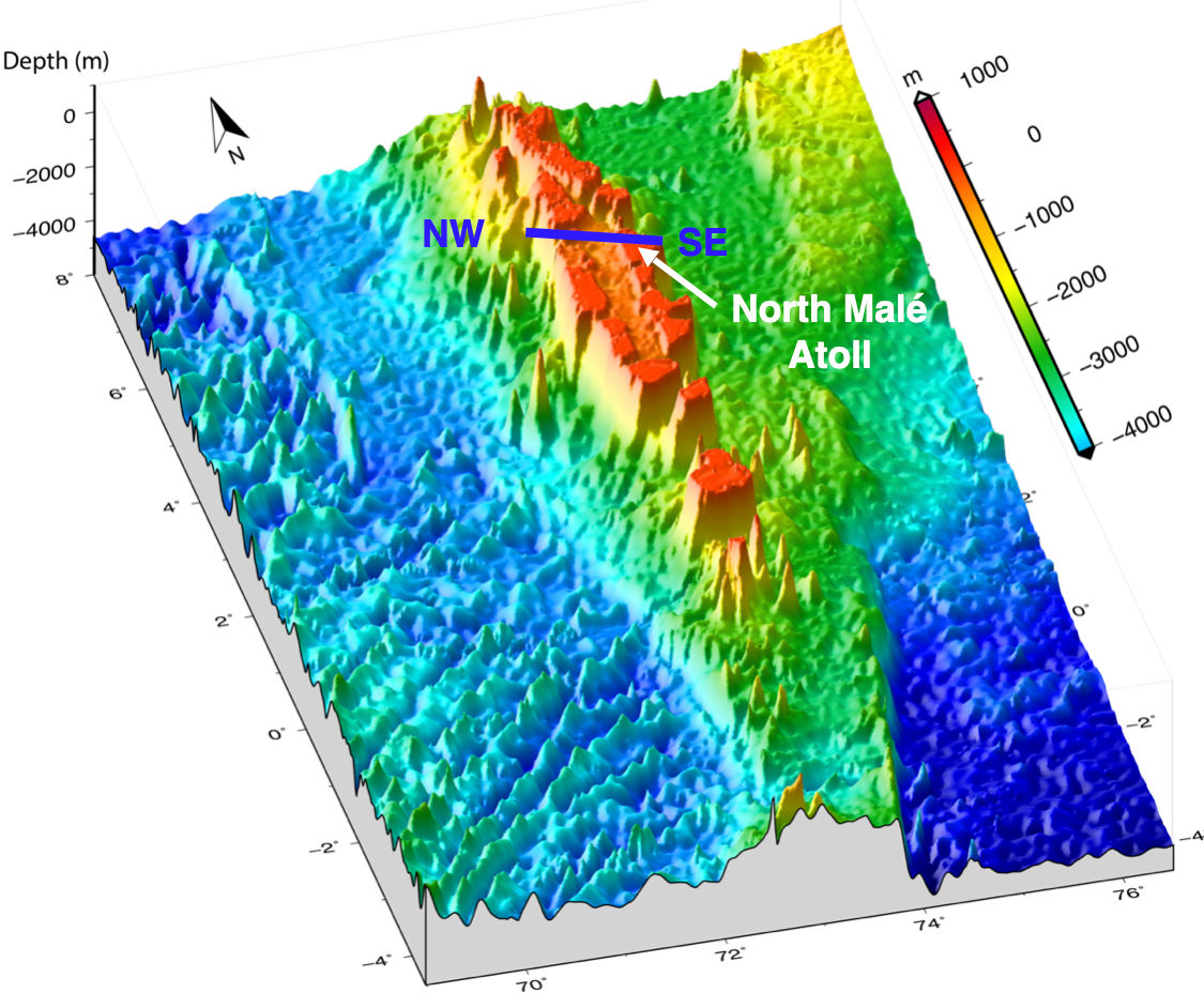
"These tiny atolls are just the last, last, last phase of this very long-term evolution of this reef system," Droxler explained. "The atolls have nothing to do with the volcanic plateau. It's only the last half a million years, while this entire carbonate edifice is 55 million years long."
The scale of this hidden structure only became clear because of the oil industry. Two companies explored the Maldives for petroleum: Elf Aquitaine in the early 1970s, and Royal Dutch Shell in the late 1980s. Neither found oil. But by firing sound waves into the sea floor and recording the echoes – a technique called seismic surveying – they mapped the rock layers kilometres below the surface. Their drill cores and data revealed the full architecture of the platform for the first time.
The Elf Aquitaine well in southwest North Malé atoll penetrated 2.1 kilometres of carbonate sediment before hitting weathered basalt, a dense volcanic rock, the top of the volcanic basement, which was dated at 57 to 55 million years old. Southeast of Ari atoll, the Shell well went deeper: 3.3 kilometres of reef limestone sitting atop ancient volcanic rock.
"Shell spent tens of millions of dollars for this," Droxler said. "And we think that it didn't cost anything to acquire this data."
Droxler, then a young geologist at Rice University in Houston, the capital of the oil and gas industry, was able to send a PhD student to work at Shell's research lab and access the seismic data directly. In 2004, they published an atlas documenting the full 55-million-year evolution of the Maldivian carbonate platform.
"Without this access to this data, we would not know anything about the origin of the Maldives," he said. "If no companies would have come here to explore for oil, we would not even know."
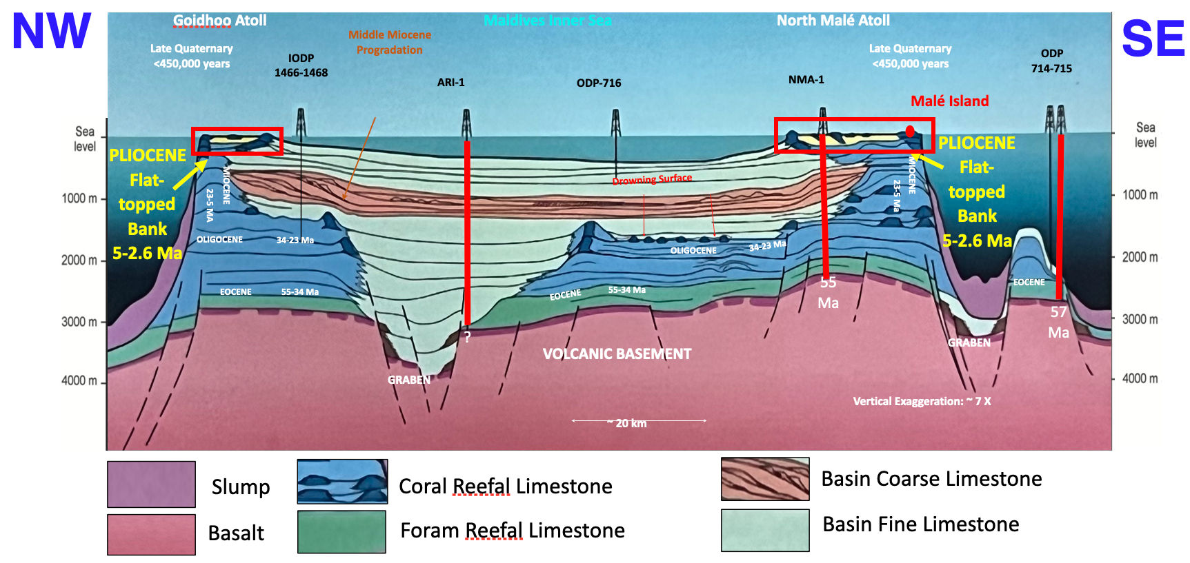
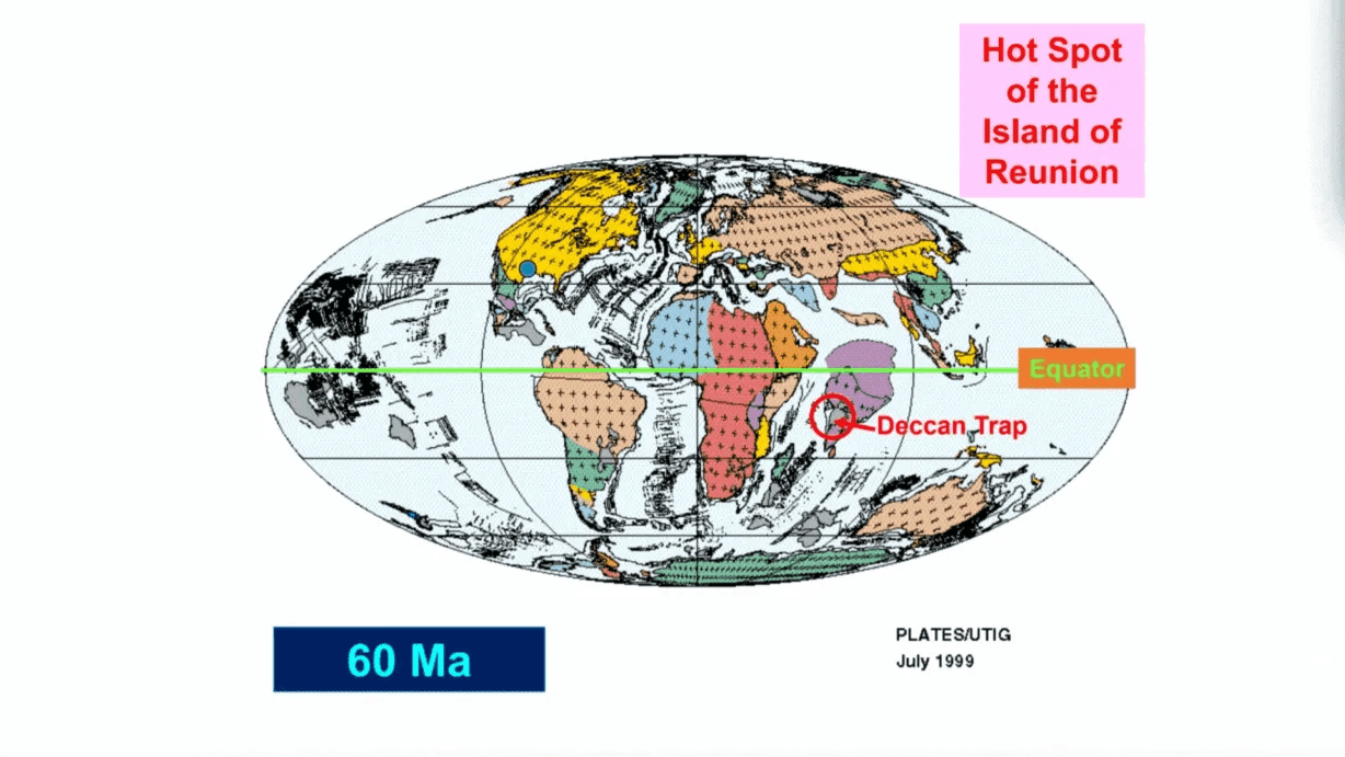
Beneath the limestone lies a volcanic plateau formed 55 to 57 million years ago, when the tectonic plate carrying what would become the Maldives drifted over a geological hotspot. That same hotspot now sits under Réunion island, 4,000 kilometres to the southwest. The trail it left behind – the Deccan Traps, the Laccadives, the Maldives, Chagos, Mauritius – traces the Indian plate's long journey northward.
What Darwin got wrong was the role of undersea volcanoes in shaping atolls. They are too ancient and buried too deep. The bowl-shaped atolls with their raised rims and central lagoons were carved by something else entirely.
"Atoll" comes from the Dhivehi word atholhu, which originally connoted the palm of the hand, according to the book. Its first recorded use in English was as "atollon" in 1625. "I always ask people, look at your hand," said Droxler. "What do you see? You see the lagoon and you see the raised rim. You can have an atoll on your palm of your hand."
The sculpture
Around 2.6 million years ago, major ice ages began in the Northern Hemisphere. Sea levels dropped dramatically, at times falling 120 metres below present levels. During earlier, calmer periods when seas were stable, reefs had grown evenly across the surface of the submerged platform, filling in any lagoons and producing broad, flat banks of limestone. Those banks stood exposed to air and rain for about two million years.
"Limestone being very unstable, when it rains, the rain is slightly acidic," Droxler explained. "So it's going to start dissolving, creating blue holes. You create a morphology on these flat top banks, which has a depression in the middle, because this is where the maximum dissolution would occur, and you would create a raised rim."
The evidence is visible in the present day. Mapping conducted around Malé in 2002 revealed dissolution features, blue holes, and terraces recording ancient sea level positions, all of which were signatures of prolonged exposure to air and rain.
Twenty thousand years ago, at the peak of the last ice age, you could have walked across the floor of North Malé atoll. The lagoon, the rim, and the channels between islands were all dry land, a flat limestone plain bounded by cliffs tens of metres high, stretching to the horizon.
That mapping was conducted after a more immediate crisis. In 2002, a jetty on the northeast corner of Malé collapsed overnight. The government asked Droxler's team and a Swiss geotechnical company to survey the area. They found the collapse was not an isolated event. Multiple slope failures had occurred along that corner, where the sea floor drops steeply from near the surface to 60 metres.
"A friend of mine owned that company," Droxler recalled. "He would say, in Switzerland, we would never even think of building a building on the edge of a slope which is from zero to 60 metres and has failed several times. We will never do this." The company advised monitoring the site continuously and to build nothing there. However, years later a mosque and reclaimed land expanded the capital's northeastern waterfront.
But the survey data yielded scientific treasure. Between Malé and the airport island Hulhulé, and on the slopes leading into the channel to the south, the team found karst features (dissolution marks and terraces that record where sea level paused as it rose after the last ice age). A terrace at 125 metres marked the coastline 20,000 years ago. Others at 105, 99, and 70 metres traced the water's climb upward. The same terraces appeared along the Indian continental margin off Goa, confirming that these are global records of sea level change.
The process that created these features is called karstification: the gradual reshaping of a landscape by rainwater dissolving soluble rock. It happens faster in the middle of an exposed bank than at the edges, where water drains quickly. Over hundreds of thousands of years, this carved bowl-shaped depressions with raised rims – the template for modern atolls.
"The modern atolls in the Maldives were formed only in about the last 450,000 years," the teacher notes explained, "the most recent phase of the long-term evolution of the Maldives carbonate platform. The origin of the atolls was fully disconnected from the volcanic plateau."
Five floods
Sea level rose and fell repeatedly during glacial cycles. There were five major floods in the past 450,000 years. Each time the carved banks flooded again, coral colonised the raised rims first. They were closest to sunlight and ocean nutrients, ideal for reef growth. Each subsequent ice age exposed the banks again, and dissolution deepened the central lagoons further.
"Corals love to be on a margin, on a high," Droxler said. "So they would colonise this raised rim of this dissolution morphology. But it doesn't last very long – this warm period like we live today is usually about 12 to 15,000 years, and sea level goes down again. So even this reef is partially dissolved again."
The cycle repeated, reinforcing the atoll shape each time. "If you go on North Malé atoll, and if we drill the margin, you should find about four or five sequences of coral exposure, coral exposure, coral exposure, coral exposure," he added.
The model has been proven in the Pacific, where nuclear testing programmes inadvertently produced detailed geological data. In Mururoa, where France conducted its tests, extensive drilling on the atoll margins found exactly the pattern the model predicts: repeated cycles of reef growth and exposure, roughly every 100,000 years.
Young islands
Malé began forming less than 4,500 years ago. The island most likely took its current shape only in the past 2,000 years, making it younger than the pyramids of Giza.
"The islands of the Maldives Archipelago only formed in the last 5,000-4,000 years as the results of the local emergent accumulations of reefal cobbles, pebbles, and sands behind the active coral reefs, when the rates of sea level rise slowed down dramatically," the book stated.
Before that slowdown, there was nowhere to stand. Reefs were growing vertically, constantly chasing rising water. Only when the seas stabilised could debris accumulate behind reef crests, vegetation take hold, and islands emerge.
Research by Paul Kench, cited extensively in the teacher materials, documented this process across multiple atolls. His work also contains a counterintuitive finding that challenges the dominant "sinking islands" narrative.
"In spite of the fact that sea level is rising, most of the islands he looked at here in the Maldives, but not only in the Maldives, but also in the Pacific – these islands don't seem to be shrinking," Droxler noted. "Even after the tsunami of 2004, he realised that these big waves would have brought up material from the offshore and piled it up in the middle of the islands. So in a way, the islands have been raised naturally because of this tsunami."
The islands shift, grow, erode, and reform in response to changing conditions. Kench's research on Kandahalagalaa, a small island in Huvadhoo atoll that formed less than 2,000 years ago, found that island area changes of around 40 metres over the past 50 years – a period of rising seas – were modest compared with shifts of 200 metres or more since the island first formed, when sea level was relatively stable.
Why it matters now
The book walks students through climate projections for 2100, connecting island formation directly to island futures.
"The past is always the answer for the future," Droxler said. "You can predict better the future if you know what has happened in the past."
Current sea level rise is accelerating. Global average sea level has risen by about 260mm over the past 140 years, but the rate is climbing sharply. Satellite measurements since 1993 show the increase decade by decade: 2.27mm per year, then 3.29mm, and in the most recent decade, 4.68mm per year. The geological record shows coral reefs can keep pace with rise of around 13mm per year. They managed it between 10,000 and 6,500 years ago as seas rose rapidly after the last ice age.
But there are limits. The record also shows that ice sheets can collapse instead of melting slowly.
"At 14,500 years, sea level was rising about 14 metres in less than 500 years," Droxler explained. "So you are talking about rise of sea level of metres per century. When you're in the Maldives, it tells you this is not too good if this would happen."
The meltwater pulse events are recorded in coral cores from Tahiti, Barbados, the Great Barrier Reef, and Hawaii. They prove that rapid, dramatic sea level rise has occurred naturally. The question is whether human-driven warming could trigger similar events.
"We have added as much CO2 in the past few decades as the amplitude from cold to warm during natural glacial cycles," Droxler observed. The current atmospheric concentration of 428 parts per million is far above the 280 ppm of pre-industrial warm periods. "We are making an interesting experiment for a scientist. No doubt we are changing the atmospheric composition of greenhouse gases, and at a rate which, according to colleagues who have worked on this, we never did it so fast."
The teacher materials lay out scenarios calibrated against the geological record. At a rise of 0.43 metres by 2100 – corresponding to a rate of about 5.35mm per year – natural islands would struggle to persist, facing conditions equivalent to 5,000 years ago when islands first began to form. At an intermediate-high projection of 1.1 metres, corresponding to 12.5mm per year, islands would likely be overwhelmed and disappear, though coral reefs should still be able to keep pace as they did between 8,000 and 6,000 years ago. At extreme scenarios of 1.8 to 2.4 metres, with rates of 22.5 to 30mm per year, even coral reefs would struggle, facing conditions comparable to the meltwater pulses that drowned reefs 14,500 years ago.
"One main and important question remains how the low relief coral islands and even the atolls themselves will be able to survive future sea level rise," the teacher notes concluded.
Rising seas are not the only threat. Warming ocean temperatures are triggering more frequent coral bleaching events, while increasing CO2 absorbed by the ocean is lowering its pH, acidification that reduces the ability of corals to build their calcium carbonate skeletons. Local pressures from sewage, coastal development, and overfishing compound the damage.
Diamonds on the soles of his shoes
Droxler first came to the Maldives in 1987, aboard a research vessel called the JOIDES Resolution, a ship leased from an oil company for the Ocean Drilling Program. He was 33 years old. He had just completed a PhD studying carbonate platforms in the Bahamas.
The Maldives were not supposed to be on the itinerary. The expedition was designed to drill near Mauritius and in the equatorial Indian Ocean. Droxler submitted a secondary-priority proposal to add a single site in the Maldives, "meaning the chance to have it is almost zero," he said, because expeditions typically run over schedule.
Then Mauritius held an election. The new government suspected the American research vessel was a CIA operation and refused to grant drilling authorisation within Mauritian waters. The ship suddenly had time to fill.
"I remember the eureka moment," Droxler recalled. "We went from Chagos. I went to the upper deck of this big ship and I was just like – if I had been on drugs I was so excited." He was listening to Paul Simon's Graceland album, released the year before. "Diamonds on the Soles of Her Shoes" was playing. "It was just amazing. And I'm here now after all of this."
That accidental drilling confirmed the volcanic basement beneath the Maldivian carbonate platform and opened nearly four decades of research. The cores showed that the volcanic plateau had once been exposed land, 55 to 57 million years ago, before slowly subsiding as the reef limestone accumulated on top.
In the years since, Droxler has returned repeatedly, to conduct the 2002 mapping survey around Malé, to advise the government on filing a claim to an extended continental shelf in 2010, and for the 2023 Fulbright residency that produced the curriculum.
Cores are gold
When Droxler arrived for the residency, he asked a question he had been asking for years: did anyone keep the geological cores from the construction of the Chinese-built Sinamalé bridge? It required drilling deep into the sea floor to understand the rock before setting foundations. Those cores – cylinders of rock pulled from boreholes – contain geological records stretching back hundreds of thousands of years.
"I was already asking, do you know of any boreholes on the Chinese bridge?" he recounted. "Nobody could help me. They would say, the Chinese came here and they built a bridge. And very few people from the Maldives were involved in this."
But an earlier project, funded by the Maldivian government to prepare bid documents, had produced a different set of cores. A series of boreholes had been drilled from a few metres of water depth in southwest Malé to 48 metres deep in the channel, reaching 125 metres below the sea floor. It was potentially a million years of geological record.
Droxler learned of their existence through connections to the previous government. Then-Construction Minister Mohamed Aslam, himself a geoscientist, made a phone call. "Tomorrow you're going to go to Thilafushi and there's beautiful boreholes there," Droxler was told.
What he found on Thilafushi was both thrilling and distressing. The cores had been sent to Dubai for geotechnical analysis, then returned and stored in a partially open structure with one wall and a roof. They had been mixed up, labels erased by exposure. Some were in wooden boxes that termites had destroyed.
"When I arrived there, some of the labels were erased, they were mixed up," he recalled. "These cores are gold for us."
With help from the ministry and about 10 workers, Droxler spent his residency preserving what he could: sorting, re-boxing, and cataloguing 13 boreholes. Nine were moved to private storage in Malé. Four remained on Thilafushi when he ran out of time. The cores later had to be moved again, and are now stored in a warehouse at the airport managed by Maldives National Defence Force.
Processing them – cutting them lengthwise, dating the rock layers, identifying the cycles of coral growth and exposure – could help confirm whether the same patterns visible in Pacific atolls hold true in the Indian Ocean. A new drilling by the Indian company building the Thilamalé bridge has produced additional cores reaching 120 metres deep, and Droxler was working in late 2025 to gain access to those as well.
"These boreholes were there rotting, decaying," he said. "They would have been probably completely disregarded at some point because nobody would know."
A different kind of education
"The goal of the book is education at the public school level – not to teach anymore about the Darwin model the way it was taught," Droxler said. "But also to show that science is not a stable knowledge. We learn, and based on what we learn, we need to adapt our models. This is a good case where, by teaching this model again and again, knowing that we have other data sets which show it's an obsolete model – it's not really giving a good education."
The book is structured in five sections, progressing from elementary through high school. Early activities ask students to observe features of their own islands. Later sections introduce the evidence – drill cores, seismic imaging, the glacial record – and guide students through the reasoning that built the modern model.
"It took us a year and a half to do this," Droxler said of the curriculum project. Working with Maldivian educators who understood both the science and the school system, he translated decades of research.
"By using up-to-date research data and evidence, this guide ensures that students gain a clear understanding of the natural processes shaping the development of the atolls and islands in the Maldives," the authors wrote in their introduction.
"Incorporating the latest research into your lessons will empower students to become well-informed, scientifically literate citizens."
Discussion
No comments yet. Be the first to share your thoughts!
No comments yet. Be the first to join the conversation!
Join the Conversation
Sign in to share your thoughts under an alias and take part in the discussion. Independent journalism thrives on open, respectful debate — your voice matters.
Support Independent Journalism
Help us keep the news free and fearless
Give once
$
or
Become a memberfrom $5/month

