El Niño is coming. Here's what it means for the Maldives.
A narrow window to prepare and a history worth heeding.
Artwork: Dosain
08 Jun, 18:03
Over the past week, the news has been hard to miss. On 2 June, the World Meteorological Organisation (WMO) confirmed what climate scientists have been watching build for months: El Niño is now developing, with an 80 percent chance through August and around 90 percent for the rest of 2026. Most modelled scenarios suggest it will be at least moderate in strength, and possibly strong.
But what does that actually mean for us here in the Maldives? Should we be concerned? And is there anything we can do about it? The short answers are: quite a lot, yes and very much so.
What is El Niño?
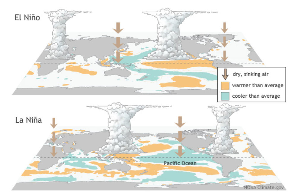
Think of the Pacific Ocean as a giant engine that helps drive the world's weather. Normally, warm water sits near Australia and Indonesia, while the eastern side of the Pacific, near South America, stays cooler. El Niño is what happens when that balance flips: the warm water shifts east, and the knock-on effects travel across global weather patterns, changing rainfall and temperatures far beyond the Pacific. When the opposite occurs and the eastern Pacific cools further than normal, that is La Niña. Together, these two opposing phases are known as ENSO – the El Niño–Southern Oscillation.
It is not a storm. It is a slow shift in ocean temperatures that builds over months and can last the better part of a year.
It does not hit us straight away
There is one thing worth understanding: El Niño does not arrive in the Maldives the moment it develops in the Pacific. Historical patterns suggest it takes roughly three to four months before the effects begin to register locally.
This means an event strengthening in the Pacific between June and August would begin making its presence felt here around September to November, coinciding with the latter half of Hulhangu, the southwest monsoon.
The Indian Ocean has its own version of 'El Niño'
El Niño does not work alone when it comes to the Maldives. There is a second, less talked-about climate phenomenon that plays an equally important role in our region: the Indian Ocean Dipole, or IOD.
Picture the Indian Ocean as a bathtub. The IOD is what happens when the water tilts – one end warms up while the other cools down. The Maldives sits roughly in the middle of this tilt, which means we feel it acutely. When the western end, near East Africa, warms and the eastern end near Indonesia cools – what scientists call a positive IOD – ocean temperatures around the Maldives rise sharply. That warming is what drives coral bleaching and, in severe cases, mass mangrove die-offs from saltwater intrusion and rapid sea-level surges.
Fishermen notice it too: tuna dive deeper, following the food chain away from the warm surface water and catch yields drop as a result. Shorelines take a hit as well, with accelerated beach erosion and disrupted sand movement around islands. When the tilt goes the other way, a negative IOD, conditions broadly normalise or even improve for reefs and fisheries.
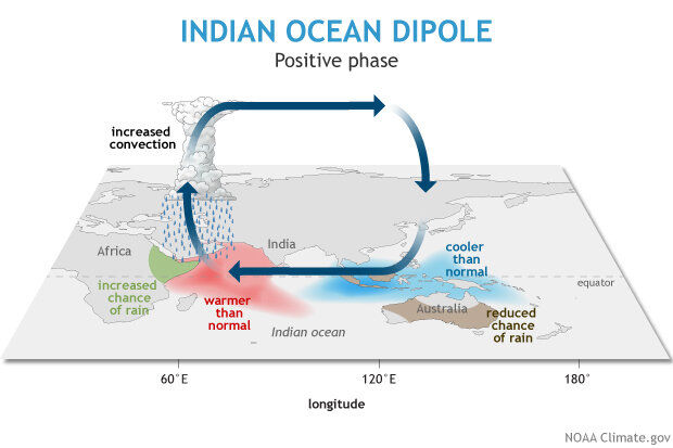
The IOD is its own natural cycle, independent of what happens in the Pacific. But El Niño and La Niña can influence it. As El Niño develops, it tends to alter wind patterns over the Indian Ocean in a way that nudges the IOD toward its positive, warmer phase. When that happens, the two drivers stack on top of each other, and the effects on the Maldives are compounded. La Niña, on the other hand, tends to push the IOD in the opposite direction, which can actually dampen conditions locally.
What history tells us
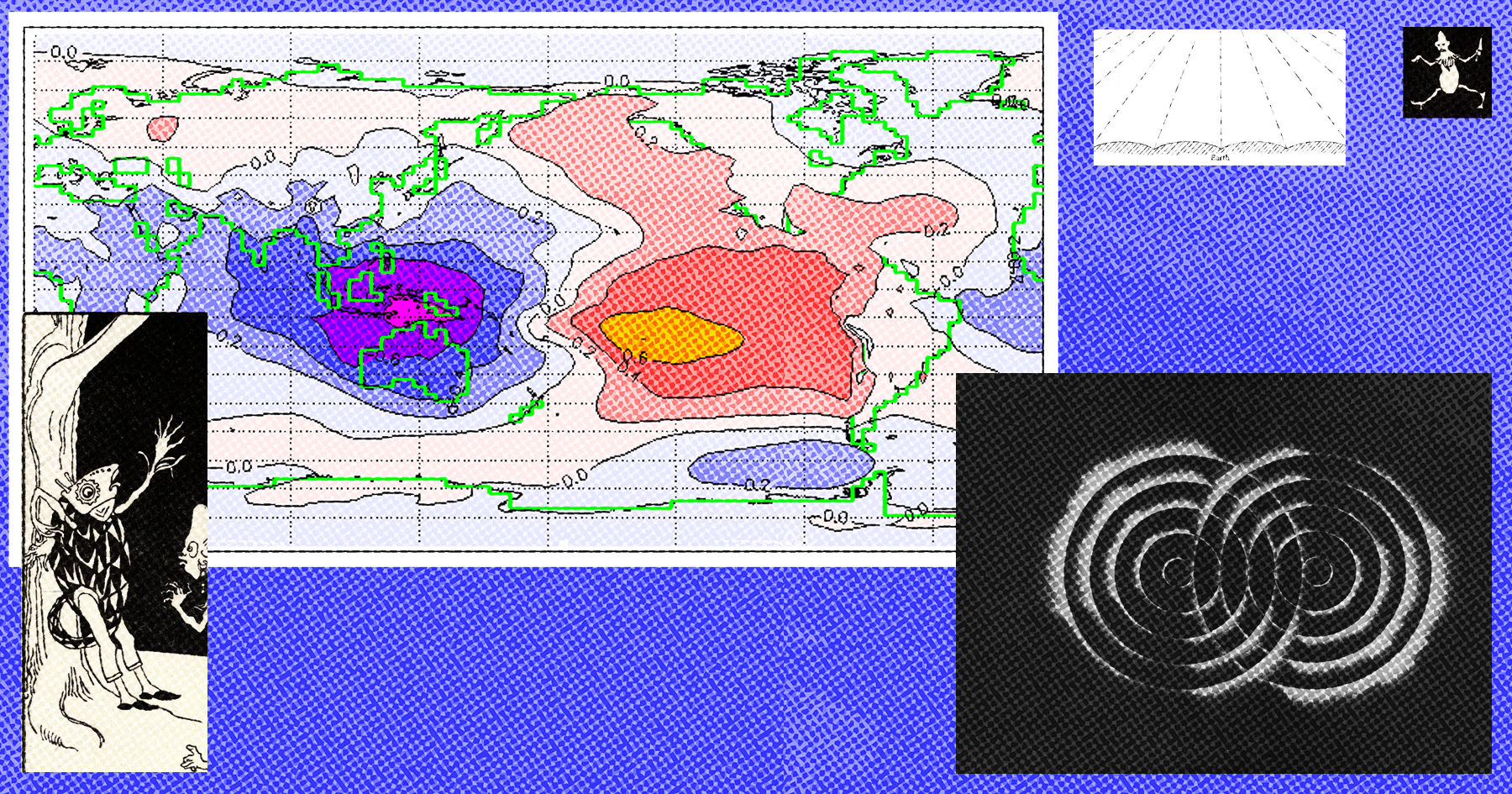
The Maldives has been through this before, and the historical record makes for sobering reading. The table below shows past history of IOD and ENSO Events – the pattern it reveals is hard to ignore.

In 1997–98, a powerful El Niño coinciding with one of the strongest positive IOD events on record, bleached up to 90 percent of the country's reefs – the worst ecological event in the archipelago's recorded history. In 2015–2016, the combination repeated: ocean temperatures soared, over 70 percent of reefs were severely damaged and the structural integrity of reefs acting as natural coastal buffers was significantly compromised.
Then in 2019-2020, the IOD delivered a different kind of blow. An extreme positive event drove sea levels around the Maldives to record highs – rising at a rate more than five times faster than mangrove ecosystems could keep up with through natural sediment build-up. The resulting saltwater intrusion stressed mangrove root systems to breaking point. By 2020, roughly a quarter of all mangrove-containing islands in the Maldives had experienced significant dieback. Mangroves matter here because they stabilise coastlines, filter water and provide nursery habitat for fish.
Most recently, 2023–2024 brought a fourth recorded global mass bleaching event, with central atolls observing 40 percent coral mortality, though southern reefs showed notable resilience.
The thread running through is the same: coral bleaching, reef degradation, mangrove dieback and coastal erosion. The worst episodes have consistently occurred when a strong El Niño or an extreme IOD, or both together, pushed ocean temperatures and sea levels beyond what these ecosystems could absorb. It is rarely one driver alone. It is the combination, the intensity and how long it lasts.
So what does 2026 look like?
El Niño is confirmed and strengthening. The IOD is currently neutral (see below).
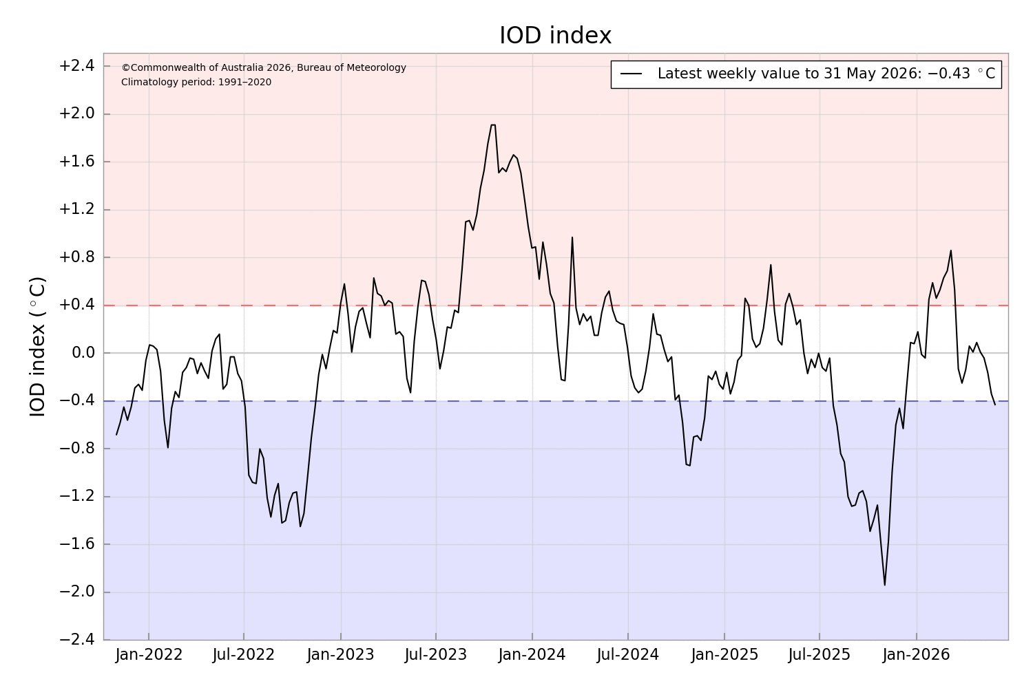
Those two facts together define the range of what this season could bring – and the difference between the two scenarios is significant.
If the IOD stays neutral, we are looking at a moderate to strong El Niño playing out without a compounding driver in the Indian Ocean. The latest 34th session of the South Asian Climate Outlook Forum (SASCOF-34), hosted in Malé in April, forecasts below-normal rainfall across most of South Asia during the June to September monsoon season.
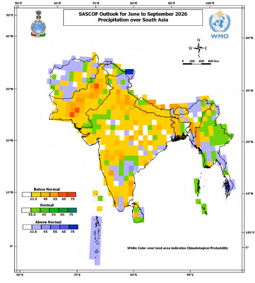
The Maldives itself is forecast to receive slightly above-normal rainfall during this period – which is, on balance, the better end of the spectrum, locally.
However, the regional picture carries consequences that may be felt here regardless. The Maldives relies heavily on South Asia, and India in particular, for staple food imports including rice, flour and onions. When monsoon failure or drought conditions stress agricultural output across the subcontinent, the effects can travel quickly in the form of supply disruptions, export restrictions and price increases. Historically, such pressures have translated into food security challenges here within months.
On the marine side, sea surface temperatures will warm, placing reefs already weakened by the 2023–2024 bleaching event under renewed thermal stress. Tuna catches are likely to be affected as fish follow cooler, deeper water. These are real risks – difficult for fishing communities and concerning for reef recovery – but based on current forecasts, not in the same category as what 1998 and 2016 delivered. That distinction matters: it is precisely the kind of forward warning that allows fisheries operators, reef managers and coastal communities to adjust before conditions peak.
If the IOD tips positive, which some models suggest is possible, the picture changes materially. A positive IOD developing alongside a strengthening El Niño is precisely the combination that has driven every major bleaching and ecological crisis in the Maldivian records. Reefs that are in recovery after 2023–2024 would face thermal stress with very little buffer and the southwest monsoon across South Asia would be further disrupted.
What 2024 demonstrates is that the tools and climate information needed to navigate this tension already exist. Seasonal forecasts, early warning systems and shared information between developers, regulators and communities can support more proportionate, better-timed responses. The forecast window we have now is exactly the kind of signal that enables robust, anticipatory decision-making before conditions on the ground demand a reactive one.
Equally, the mitigation measures already required by law for coastal construction deserve more consistent enforcement regardless of season. Sediment screening, containment and the regulation of rainbowing – a reclamation technique strictly governed by environmental and municipal guidelines – are among the most critical. These are not measures invented for El Niño years. They are baseline requirements that become acutely consequential when reefs are already under heat stress. During periods of elevated thermal stress, when sediment tolerance is at its lowest, regulators should be especially vigilant about whether those conditions are being met.
The honest answer, as of early June, is that we do not yet know which scenario will play out. The models will sharpen in the coming weeks, and the Maldives Meteorological Service monthly outlook is the right place to track that shift as it happens. On the reef monitoring side, the Maldives Marine Research Institute's Coral Watch programme offers a practical way for divers, resorts and marine enthusiasts to contribute directly to nationwide bleaching surveillance – reporting early warning signs from the water before they show up in formal assessments.
What history tells us is that the window between now and September is not a time for passive monitoring. It is a time for preparation. Fisheries operators, developers and community leaders all have decisions to make – about reef protection, construction scheduling, water management, food supply planning, early warning systems and contingency plans – that are considerably easier to make now than after the impacts start to show.
The science has given us the forecast range. What we do with it is up to us.
For updated climate outlooks specific to the Maldives, visit the Maldives Meteorological Service at https://www.meteorology.gov.mv/downloads#reports
For more information and contributing to the Maldives Marine Research Institute's Coral Watch programme, visit coraldatabase.gov.mv
Ahmed Shabin is a meteorologist and climatologist with nearly a decade of experience at the Maldives Meteorological Service, including a fellowship at the European Centre for Medium-Range Weather Forecasts (ECMWF). His current role as Secretary General at Maldivian Red Crescent reflects a broader interest in how climate risk translates into humanitarian work – an interest that informs, but does not direct, the views expressed here.
Discussion
No comments yet. Be the first to share your thoughts!
No comments yet. Be the first to join the conversation!
Join the Conversation
Sign in to share your thoughts under an alias and take part in the discussion. Independent journalism thrives on open, respectful debate — your voice matters.
Support Independent Journalism
Help us keep the news free and fearless
Give once
$
or
Become a memberfrom $5/month

