Ice ages, not volcanoes: how the Maldives really formed
Darwin's 1842 theory is elegant. Drill cores tell a different story.
Artwork: Dosain
14 Apr, 16:38
A companion explainer to our feature on the new science being taught in Maldivian schools.
Didn't we already know how the Maldives formed?
Sort of. The theory most people learned – in school and in textbooks around the world – comes from Charles Darwin. In 1842, he proposed that atolls form when a volcanic island slowly sinks into the ocean. As it sinks, coral reefs grow upward around the rim, eventually forming a ring-shaped reef with a lagoon in the middle. When the volcano disappears under the sea, the reef remains.
It was an elegant and intuitive idea. But Darwin was restricted to working from nautical charts. He could never drill into an atoll to see what was underneath.
So was Darwin wrong?
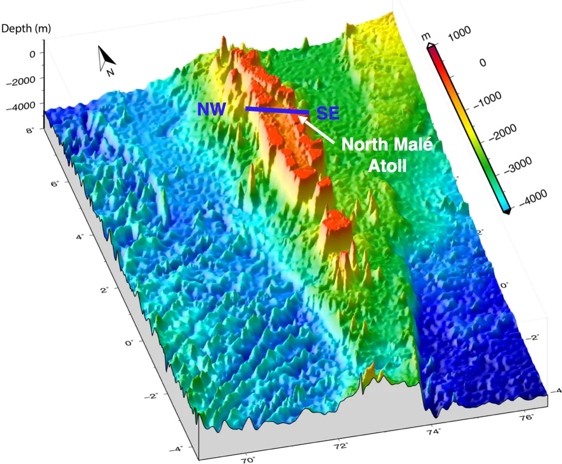
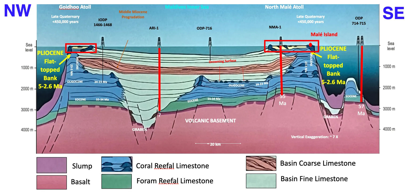
Not exactly. His theory makes sense for some Pacific atolls that sit directly on volcanic cones. But in the Maldives, the volcanoes are buried under two to three kilometres of limestone. They are 55 million years old. The atolls we see today are less than 450,000 years old. The two have almost nothing to do with each other.
Darwin didn't get the mechanism wrong so much as the timescale. He thought the process was one continuous sequence: volcano, fringing reef, barrier reef, atoll. In reality, there was a gap of tens of millions of years between the volcanic foundation and the atolls growing on top.
Then what actually shaped the atolls?
Ice ages and rain.
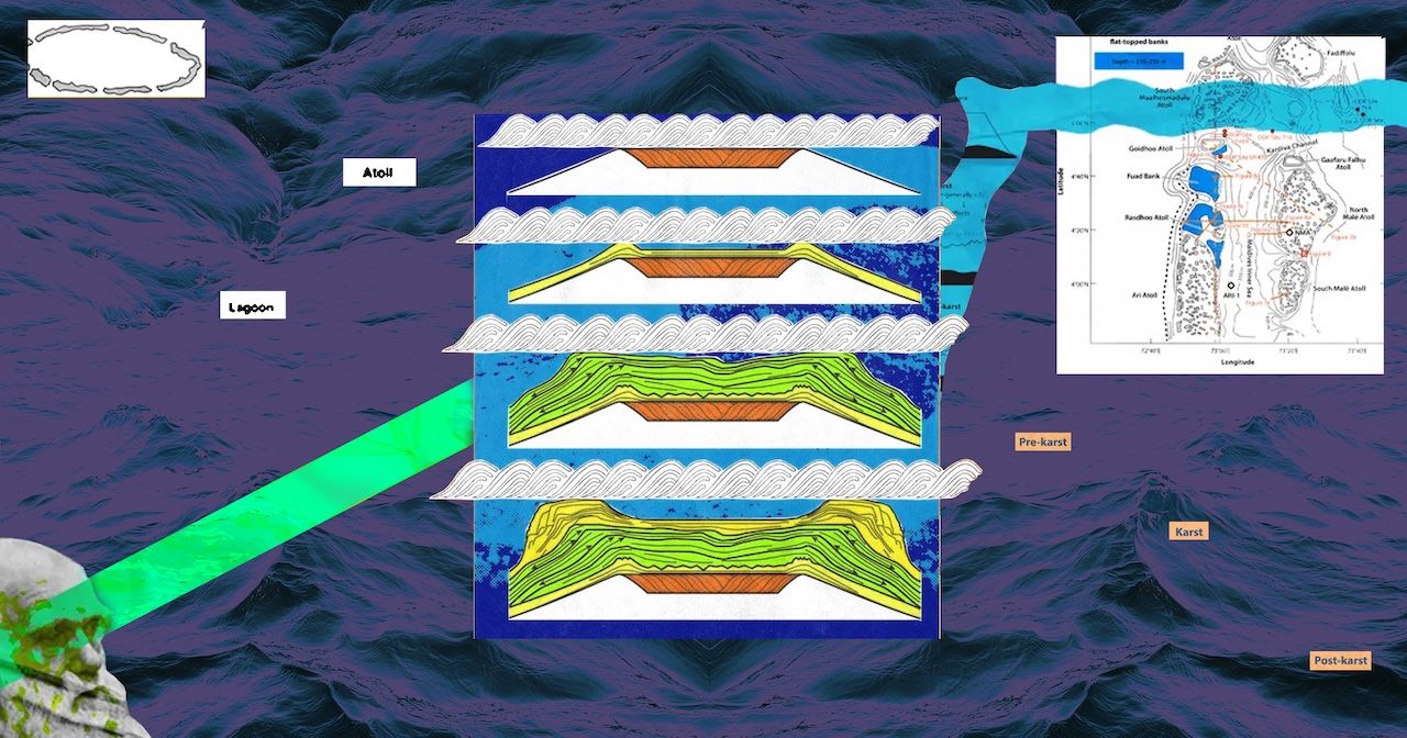
Starting about 2.6 million years ago, the Earth entered a period of repeated glaciations. Huge ice sheets grew in the Northern Hemisphere, locking up so much water that global sea levels dropped by as much as 120 metres. The limestone platforms that would become the Maldives – broad, flat banks of old reef rock – were left exposed to the air.
It rained on the exposed limestone. Because the rainwater was slightly acidic, it dissolved the rock. Over about two million years of exposure, the rain carved the flat banks into bowl shapes: deeper in the middle with raised edges. Think of cupping your palm, the depression in the centre and the raised rim around it, that is the template for an atoll.
At the peak of the last ice age, 20,000 years ago, you could have walked across the floor of North Malé Atoll. The lagoon, channels, and the reef rim were all dry land, a limestone plain stretching to the horizon.
How did those bowls become the atolls?
Sea level did not just drop once. It went up and down in cycles, every 100,000 years, as ice sheets grew and melted. In the past 450,000 years, the carved limestone banks were flooded about five times.
Each time the sea rose and covered the banks again, corals started growing. They grew fastest on the raised rims because that is where conditions are best: the edges were closest to sunlight, to nutrients carried by ocean currents, and to the open water that corals need.
But each warm period only lasted about 12,000 to 15,000 years before sea levels dropped again and the banks were exposed once more. The rain went back to work, deepening the central lagoons. Then the sea rose again and corals recolonised the rims.
Five cycles of flooding, coral growth, exposure, and dissolution reinforced the atoll shape each time, making the rims higher and the lagoons deeper.
How do we know this?
From several lines of evidence. Oil companies explored the Maldives in the 1970s and 1980s. They drilled wells that went more than two kilometres down through limestone before hitting volcanic rock. Those cores let scientists read the geological record layer by layer.
Then there were seismic surveys. By firing sound waves into the sea floor and recording the echoes, researchers mapped the rock structures kilometres below the surface. It is the same technique used to find oil and gas.
Surveys around Malé have found karst features – blue holes, dissolution marks, terraces – on the sea floor between Malé and Hulhulé. These features only form when limestone is exposed to air and rain, proving the platform was once above water.
In the Mururoa and Bikini atolls in the Pacific, extensive drilling programmes (originally for nuclear testing) found exactly the pattern the model predicts: repeated layers of coral growth alternating with exposure surfaces, about every 100,000 years.
What about the islands? When did they appear?
The atolls – the ring-shaped reef structures – are up to 450,000 years old. But the islands sitting on top of them are extremely young. Most are less than 4,000 years old. Some formed less than 2,000 years ago.
Why so young?
Islands could not form until sea level rise slowed down.
After the last ice age ended about 20,000 years ago, sea levels rose rapidly, by about 120 metres over 14,000 years. During this period, coral reefs were growing upward as fast as they could, trying to stay in shallow sunlit water. There was no stable surface for sand and rubble to pile up on.
Around 5,000 years ago, the rate of rise slowed dramatically. Sea level more or less stabilised. The reefs, no longer needing to grow upward, began to spread sideways. They produced more sediment than the currents could carry away. Sand, coral rubble, and pebbles accumulated behind reef crests. Vegetation took root and the islands emerged.
Are the islands sinking?
Research by Paul Kench across the Maldives and the Pacific has shown that many natural islands – those not heavily modified by construction – have not been shrinking despite decades of measured sea level rise. Some have shifted position or changed shape, but their total area has remained stable or even grown.
Islands are accumulations of loose sediment produced by living reefs. As long as the reefs are healthy and producing material, the islands can adjust. After the 2004 tsunami, researchers found that the waves had carried material from offshore and deposited it on top of islands, effectively raising them.
The islands are dynamic, constantly being reshaped by waves, currents, storms, and the health of the reefs around them.
So what is the actual threat?
Sea level rise is accelerating. Satellite measurements show the rate has roughly doubled in 30 years, from about 2.3mm per year in the 1990s to nearly 4.7mm per year in the most recent decade. The geological record shows that coral reefs can keep pace with rise of about 13mm per year. But at higher rates, reefs fall behind and eventually drown.
The worst-case scenarios for 2100 project sea level rise of 1.8 to 2.4 metres, with rates of 22 to 30mm per year. At those rates, reefs would struggle to survive, let alone produce the sediment that builds islands.
But sea level is not the only threat. Coral bleaching, caused by warming ocean temperatures, is killing the reef organisms that produce island-building sediment. Ocean acidification, caused by the absorption of CO2, is making it harder for corals to build their calcium carbonate skeletons in the first place. Sewage, dredging, overfishing, and poorly planned coastal development are damaging reefs.
The geological record shows the Maldives survived dramatic sea level changes before. But the combination of rapid sea level rise with degraded reef health is new. If the reefs that build the islands are weakened at the same time that sea levels are rising faster, the natural island-building process may not be able to keep up.
What does understanding all of this change?
The islands are products of a process rather than fixed objects. They have always been forming, shifting, and reforming. They are not permanent features that are now being destroyed. They are dynamic landforms being shaped by forces that continue today. Policy responses that treat islands as static – seawalls, land reclamation – work differently than responses that try to maintain the natural processes that build and sustain islands.
The atolls and the islands are two separate things on two very different timescales. The atolls, carved by ice ages, are geologically robust structures. They have survived multiple cycles of flooding and exposure over hundreds of thousands of years. The islands, built from loose sediment in the past few thousand years, are far more fragile. Protecting the islands means protecting the reefs that produce them.
Where can I read more?
The textbook Atoll and Island Formation in the Maldives by André Droxler, Mohamed Didi, Aminath Shiyama, and Fathimath Shafeeqa is being distributed to schools through the National Institute of Education.
Discussion
No comments yet. Be the first to share your thoughts!
No comments yet. Be the first to join the conversation!
Join the Conversation
Sign in to share your thoughts under an alias and take part in the discussion. Independent journalism thrives on open, respectful debate — your voice matters.
Support Independent Journalism
Help us keep the news free and fearless
Give once
$
or
Become a memberfrom $5/month

